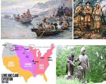
Lewis and Clark Expedition: Summary, Team, Challenges, and Importance
World History Edu presents everything you need to know about the Lewis and Clark Expedition that took place in the first few years of the 19th century. It includes summary, members of the expedition team, and the importance of the expedition.
Lewis and Clark Expedition (1803 – 1806)
Summary
In the immediate aftermath of the Louisiana Purchase in 1803, an acquisition that saw the United States of America more than double its land size, then-US President Thomas Jefferson set up the Lewis and Clark Expedition team to explore and map out the newly acquired Louisiana Territory.
At the helm of the expedition were Captain Meriwether Lewis and Second Lieutenant William Clark. Those two men, who were by the way former military men, marched westward with a team of about 40 men (civilians and military men) into a starkly unknown and dangerous territory.
The starting point of the expedition was near Pittsburgh, Pennsylvania. The Louisiana expedition team, whose journey lasted from August 1803 to September 1806, soldiered through the Continental Divide of the Americas. And after several hostile and sometimes friendly interactions with the natives, Commanders Lewis and Clark successfully made their way to the Pacific coast line. The explorers endured extremely harsh weather conditions and challenging landscape in order to accomplish such monumental feat.
The Lewis and Clark Expedition was one of the most defining endeavors undertaking by the newly-born United States of America. It was a fitting complement to the historic Louisiana Purchase deal of 1803.
The Expedition Team and its objective

Expedition Leaders Captain Lewis (left) and Lieutenant Clark
The Lewis and Clark Expedition, also known as the Corps of Discovery, was commissioned by President Thomas Jefferson a few months after the famed Louisiana Purchase in 1803.
The leadership of the corps was mandated to find a path across North American continent. Another objective of the Lewis and Clark Expedition was to map out the Louisiana Territory. It was also tasked with establishing the United States’ political, economic, and military presence in the territory. That particular goal of the expedition was aimed at warding off any European country’s claim to the newly acquired region.
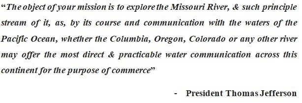
Thomas Jefferson’s directives to Commanders Lewis and Clark
Other supporting objectives of the Lewis and Clark Expedition included a host of economic, social and scientific aspirations. For example, the explorers were tasked to determine the kind of resources that the region possessed and then report their findings back to President Jefferson.
Outcome and Importance of the Lewis and Clark Expedition
President Jefferson envisaged that explorers Lewis and Clark would find a water course that was “direct and practicable” to support the burgeoning nation’s commercial and security needs.
The expedition could not find a continuous waterway (as expected by President Jefferson) to the Pacific Ocean. Rather, Lewis and Clark discovered a trail that led to the upper end of the Missouri River and then all the way to the Columbia River and finally to the Pacific Ocean.
Upon the completion of their task, Lewis and Clark submitted their findings and reports to Thomas Jefferson at St. Louis in September 1806. The findings and report included detailed maps (about 140 maps of the geography of the Northwest, maps none like ever seen before) of the territory, expedition journals, logs, and sketches.
The explorers also submitted several scientific reports about the area’s topography, plants, seeds, fauna, flora, animal species, and mineral specimen. The chief beneficiary of the Lewis and Clark Expedition’s scientific data was the American Philosophical Society.
In addition to mapping out the area, the expedition team successfully established US’s presence in the area. They were able to secure some level of diplomatic relations and trade with over 20 Native American tribes. Their report included never-before-heard details about the mountain ranges and rivers in the area.
Finally, the expedition team brought along with them a number of Native American artifact, bows, clothing, and other totems. Chief Shehaka, leader of the Mandan Indian nation, joined the expedition team on their way back home. As part of cultural exchange, Shehaka met up with Thomas Jefferson.
Planning and Preparation
President Thomas Jefferson was the chief architect and brain behind the expedition. In 1802, he tasked Congress to fund an expedition that would allow the US fully commercialize the Louisiana Territory. The US made no attempt of hiding the expedition and its intentions, thus it was well in the know of European powers such as Spain, Britain and France.
Following President Jefferson’s appeal, Congress allocated about $2,500 for the expedition. Shortly after securing funding, Jefferson established the Corps of Discovery under the command of Captain Meriwether Lewis. Jefferson was full of praise for Captain Meriwether Lewis.
As part of the preparation exercise, the president asked Captain Lewis to study medicinal cures under the supervision of physician Benjamin Rush. Captain Lewis also received his astronomy preparations from Andrew Ellicott.
Prior to the expedition, the US mint handed out special silver medals to the explorers. These medals, which had Jefferson’s face and warm messages of peace on it, were to be given out to Native Americans in the region. It was Jefferson’s way of extending a warm hand to the natives. It was also a way of introducing the Natives to the new owners (i.e. the United States) of the land. Those medals came to be called Indian Peace Medals.

The explorers did not venture into the unknown western frontier without packing up some ammunition. Lewis and Clark’s team were fully geared up and remained ready to quell any resistance to their expedition. This was one way of showing the Native Americans US’s full military prowess. Examples of the weapons included Girandoni air rifle, flintlocks, knives, and a host of other magazines. They also had on them cartography equipment, medicine supplies, gifts for the Natives, and several American flags, which were eventually hoisted in the region.
The Expedition Trail, Journey, and Map

The Lewis and Clark Expedition began in 1803 at Camp Dubios, St. Louis, Missouri
Captain Lewis was assisted by a very knowledgeable military mind in the person of Lieutenant Clark. The duo assembled a team of about 40 men, both civilians and military men. They planned setting off from Pittsburgh, Pennsylvania in late summer of 1803. From Pittsburgh, the team would make it down the Ohio River before proceeding to the Falls of the Ohio, a place where Clark would meet up with the rest of the team. From there, the team would make it up the Missouri River and all the way to the river’s headwaters.
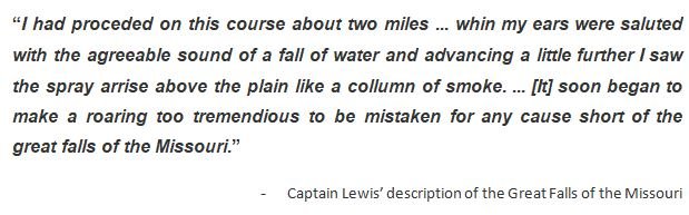
Captain Lewis’s description of the Great Falls
About 18 months later (in November, 1805), the expedition successfully arrived at the shoreline of the Pacific Ocean. The journey back home was not fraught with as much difficulty as the journey to the Pacific Ocean. The group, which had traveled about 800 miles, arrived in St. Louis, Missouri in September, 1806 to a rousing reception. Subsequently, their findings and reports were submitted to President Thomas Jefferson in the White House, Washington, D.C.
Get more: Events, Facts and Timeline of the Lewis and Clark Expedition
Challenges

Lewis and Clark on the Lower Columbia | Pitcture by Charles Marion Russell
There was a little skirmish between the expedition and the Lakota nation (i.e. the Sioux). Tensions almost boiled over into a fight after the expedition lost one of their horses. Believing that the culprit was none other than the Lakota people, the expedition readied themselves to engage. Luckily, calmer heads prevailed and the expedition team proceeded to dialog with the tribe. To their surprise, the Lakota nation insisted on receiving more gifts before granting them safe passage through their lands.
After a few bickering here and there, the two sides resolved their differences. The expedition made their way into the Arikara territory. In his journal, Clark described them as one of the most brutish people he had ever seen.
Aside from some Native American tribes refusing to grant them safe passage, the Lewis and Clark expedition team had to endure awful winter conditions. At some point in time, they were short on provisions and food items.
Finally, there was the communication barrier. This problem was slightly mitigated due to the immense assistance received from French-Canadian fur trader Toussaint Charbonneau and his Shoshone wife Sacagawea. Most likely, Sacagawea’s extensive knowledge of the terrain and her language proved very useful for the expedition group. The presence of Sacagawea, who was by the way a pregnant mid-teenager, would have assured the Natives that the expedition group was not dangerous.
Conclusion
Without a shred of doubt, the Lewis and Clark Expedition would forever be seen as a stellar accomplishment for the United States. The expedition more than supported the Manifest Destiny and Thomas Jefferson’s Empire of Liberty dreams. However, the US’s gain was the Native Americans’ loss. By venturing into the lands of the Native Americans westward, the United States of America brought (deliberately and unknowingly) caused untold sufferings for the Natives. Land seizures, destabilization of the ecosystem, diseases, suppression, and decline in the Native population are just some examples of the havoc the US brought upon the Native tribes in the region. Read more about this in theTrail of Tears – Story, Death, and Facts.
Facts about Captain Meriwether Lewis and Second Lieutenant William Clark

Facts about Captain Meriwether Lewis

William Clark Facts