Indus River: 12 Very Important Facts
Indus River facts
The Indus River is generally regarded as a river of utmost value to three very populous Asian countries – China, Pakistan and India. Starting near the Manasarovar Lake on the Tibetan highlands, China, the Indus River meanders all the way through India, Afghanistan, and then making its way into Pakistan.
Quick Facts about the Indus River
Countries: China, India, Pakistan, and Afghanistan
Source: Tibetan plateau (southwestern Tibet, near Lake Mapam)
Other names: Sindhu, Mehran, Sindhi Sindhu, Sindhu Nadi (in Hindi), and Daryā-e Sindh (in Urdu).
Mouth: the Arabian Sea, at Karachi, Sindh, Pakistan
Major tributaries: Zanskar and the Panjnad
Indus River distribution (in percentages): Pakistan – 47%, India—39%, China – 8%, and Afghanistan – 6%
Length: Approximately 2,000 miles (3,200 km)
Drainage area: 450,000 square miles (1,165,000 square km)
Annual Flow: 58 cubic miles (243 cubic km)
Record: Longest river in Pakistan; drainage is two times that of the Nile in Egypt and three times the total drainage of the Tigris and Euphrates rivers combined
Title in Pakistan: National River of Pakistan
Historical benefit: crucial during the Indus Valley Civilization
Present benefit: Meets the irrigation and fishing needs of countries such as India, Pakistan and Afghanistan.

The Indus River plays a very important role in the lives of the 300 million plus inhabitants that live in the Indus River basin. In Pakistan, for example, the Indus River holds the record of being Pakistan’s longest river, offering immense economic and religious benefits to the settlements along the river’s path. To gain a better understanding of the river, here are 12 very important facts about the Indus River:
The Source can be traced to Tibet
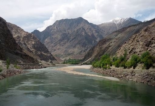
From an elevation of about 5,500 meters, the Indus River begins around the Tibetan Plateau region. It then flows about 320 km northwest into the region of Kashmir. From Kashmir, the river makes its way into the Ladak, a region near Gilgit-Baltistan in Pakistan. Once in Pakistan, the Indus River merges with the Zanskar River and then flows for about 150 miles (240 km) into the Pakistani-controlled section of the Kashmir region. While there, the Shyok River comes into contact with Indus. Subsequently, the Shigar River, the Gilgit River, the Astor River, the Kabul River, and a host of other smaller rivers and tributaries join the Indus River downstream. Ultimately, the Indus River enters the Arabian Sea near the port city of Karachi, Sindh, Pakistan.
The Indus River gets enlarged at the Punjab Plain
The plain at Punjab, a region between Pakistan and India, is what accounts for the enlargement of the Indus River. While at the Punjab Plain, the Indus River gets joined and enlarged by five very important Punjab Rivers: Jhelum, Ravi, Beas, Chenab, and Sutlej. These five rivers together form the Panjnad tributary. The enlarged Indus River then flows downstream to form the Indus River Delta, which has an area of about 41,440 square km (16,000 square miles).
Indus River Basin hosts about 300 million people
The Indus River, which has a total area of about 1.12 million square km, is absolutely vital for nations such as China, India, Pakistan, and Afghanistan.
In China for example, the Indus River Basin occupies about 1% of the size of the country. In Pakistan, however, the figure is more staggering, occupying 65% of the country’s territory. The basin occupies about 14% of the Indian territory.
In terms of the distribution of the Indus River basin, Pakistan and India have 47% and 39% of the total area respectively. China and Afghanistan have 8% and 6% of the 1.12 million square km of the Indus river basin.
And if you were to put together all the people that live in the Indus River Basin currently, the figure would amount to about 300 million inhabitants.
The River relies heavily on glaciers
Glaciers on mountain ranges are the primary source of many of the rivers that feed into the Indus River. As a result of this, the Indus River gets significantly less input during the winter season (i.e. December to February) simply because all many of those glaciers don’t get churned into those rivers. Many of these glaciers are found at Karakoram, Hindu Kush and the Himalayan mountain ranges. However, in the summer months (especially in July and August), the rise in water level of the Indus River brings quite some amount of flooding in the surrounding areas. This rise in the Indus is primarily due to the monsoon rains, which typically occur between July and September.
Over the past half a century or so, the melting glaciers in the Himalayan and Kashmir, as well as unchecked irrigation and hydroelectric projects, have contributed to the reduction of the Indus River’s flow and output.
Upper Indus can boast of carrying about 26.5 cubic miles annually
It has been estimated that the upper Indus in the Himalayas alone carries about 26.5 cubic miles of water. At that quantity, the upper Indus accounts for almost half of the entire water in the Indus River. This is far greater than the combined amount the Jhelum and Chneb Rivers in Punjab carry.
Precipitation ranges between 5 and 20 inches
The annual precipitation in the Indus river region gets to as low as 5 inches and as high as 20 inches. The region is considered one of the most arid places in the area. However, the places close to the mountains in Pakistan as well as other places in upper Indus do get adequate amount of precipitation, sometimes in the form of snow as well. In the Northwest, the rainfall during winter varies between 4 to 8 inches.
The Indus has shifted over the last seven centuries
Experts believe that the Indus that flows from the south of Punjab region into the sea has moved quite a bit. The shift has been westward bound. And this is not the only place where the course of the Indus River has shifted. Studies have shown that in the northern Sindh region, the Indus has moved about 10 to 20 miles westward in the last seven centuries alone. It is unclear what really accounts for these shifts in the course of the Indus River.
The Name comes from Sanskrit
The meaning of the name “Indus” can be traced to the name “Sindhu”, which is an ancient Sanskrit name used in Ancient India. Sindhu means “large body of water, sea, or ocean”.
As for the ancient Persians, the river was called “Hindu”, which would later become “Indos” in Greek. Finally, the Romans picked the name and called it “Indus”.
It is out of the name of the river – “Indus” – that the present-day country, India, derived its name. This shows us the historic importance of the Indus River in the Indian subcontinent.
Additionally, the Indus River was the life blood of countless communities that lived during the Indus Valley Civilization.
The Indus River gave birth to the Indus Valley Civilization
In terms of the impact it had on the world, the Indus Valley Civilization (IVC) has often been put into the elite category of greatest civilizations in human history. And like the Egyptian and Mesopotamian civilizations that were fueled by the Nile and the Tigris and Euphrates rivers respectively, the Indus Valley Civilization drew strength from the Indus River.
Commonly called the Harappan Civilization, the Indus Valley Civilization went on to grow due to the Indus River and Ghaggar-Hakra River basins spread across Pakistan, India, and Afghanistan. At its peak, the Indus Valley Civilization covered a land area of almost the size of Western Europe. Not only was the civilization large, studies have shown that it was old as well, beginning as far back as 8,000 BCE. At that age, the Egyptian and Mesopotamian civilizations begin to appear modern relative to the age of the Indus Valley Civilization.
Between 2,000 BCE and 1900 BCE, the IVC saw itself in declining. By 1800 BCE, the once large civilization of Asia was off the face of the earth. Experts have come out with several theories that border around climate change and the changing crop patterns to explain how a civilization as big as the IVC fell into decline.
The Indus Water Treaty of 1960 is what keeps the peace among the countries
On September 19, 1960, Indian Prime Minister Pandit Jawaharlal Nehru and Pakistan President Ayub Khan signed the Indus Water Treaty. The treaty, which was brokered by the World Bank, was necessary considering the tensions that brewed after the 1947 partition of British India into Pakistan and India. Prior to the treaty, a brawl ensued between Pakistan and India over the amount of water each country was entitled to.
Primarily, the disagreement had to do with the irrigation system – Bari Doab and the Sutlej Valley. The irrigation system was sandwiched between the two countries, causing Pakistan’s share of the water from the river to significantly drop after the 1947 partition. Therefore, the World Bank had to step in to resolve the issue. And so the Indus Water Treaty was born in 1960.
In the treaty’s sharing rights, Pakistan was given three western rivers of the Indus basin- the Indus, Jhelum and Chenab. The Indians were entitled to receive water flows from the three eastern rivers – the Ravi, Beas, and Sutlej.
Over the years, however, there have been sporadic conflicts and accusations thrown back and forth between the two countries over the river. For example, Pakistan made a request to India in 2018 to embark on field trip of some of the projects that were taking place at the Indian side of the Indus river basin. Pakistan has long maintained that India’s hydroelectric power projects Pakal Dul and Lower, located in Kalnai, Jammu and Kashmir respectively, breeches the Indus River Treaty of 1960. On the other hand, India believes that those projects are well within its rights.
It contributes immensely to the economy of the region
Similar to how the Indus River was important to the Indus Valley Civilization, the Islamic Republic of Pakistan currently relies heavily upon the Indus River and its tributaries for about 80% of its water needs in the agricultural sector. The river is such an important component of the Pakistani economy. The country relies on it for its irrigation, fishing, and hydroelectric power generation needs. In terms of agriculture, the Punjab province in Pakistan holds the status of the nation’s pantry because of the crucial irrigation systems that have been set up along the Indus River. In Karachi, for example, there is a large fishing habor built at the port of Karachi.
As a matter of fact, Pakistan is not the only country that uses the Indus to irrigate several millions of acres of farm lands; India and Afghanistan use the river in similar fashion. In all those three countries, the river remains the lifeblood of several thousands of communities living in the Indus River basin. The population of in those communities are in the region of 3 million.
The Indus River has been put under immense pressure
Another very important fact about the Indus River is that: The river seems to be reaching the point of no return due to extreme pressures from human activities of the past half a century or so. Take the example of cotton production in both Pakistan and India. Collectively, these two two countries account for a significant amount of the world’s cotton supply. And without the Indus River, those cotton plantations (by extension the textile industry) would have been non-existent. Economically, this may sound like a good thing; however, the immense pressures that cotton industries of those two countries put on the Indus River is very palpable.
Growing population in the region and climate change are just some of the numerous challenges that the Indus River has to contend with on a daily basis. Thus, a river that has survived for several millennia appears to be reaching a breaking point where conflicts among the countries in the region over who gets what of the river could spiral out of control.
FACT CHECK: At worldhistoryedu.com, we strive for utmost accuracy and objectivity. But if you come across something that doesn’t look right, don’t hesitate to leave a comment below.


Does the Indus really meet the sea at Karachi? My Times Atlas shows the principal point some 125 km SE of that city, and various maps of Karachi show it intersected by some minor rivers which do not even appear to connect to the Indus delta.